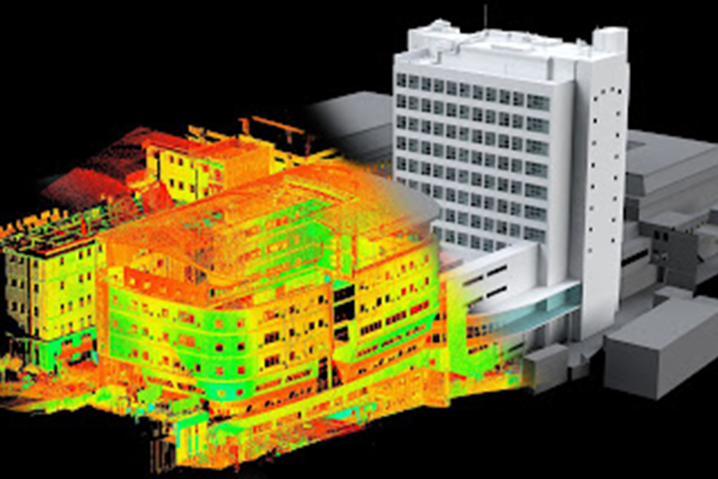
WELCOM TO
GEOSPATIAL SURVEY & MAPPING

Our surveyors has specialized in Mobile Mapping, Aerial / Drone Mapping, Engineering surveys, land development, laser scanning, mining services, spatial data management and scanning services include utility mapping, concrete scanning, dilapidation surveys, and monitoring

GeoSpatial Surveying and Mapping is a leading Survey Engineering Company in the UAE, established in 2012. Built on strong values of work ethic, honesty, and commitment to relationships, we have become one of the top organizations in the industry. We specialize in Land Surveying, Soil Investigation, Aerial Surveys (UAV/Drone Mapping), Bathymetric Surveys (Hydrographic), Underground Surveying, 3D Laser Scanning, Calibration Services, Material Testing, and Geographic Surveys, all delivered to international standards and quality benchmarks.

GeoSpatial Surveying and Mapping, established in 2007, is a leading Survey Engineering firm in the UAE, recognized for its integrity, professionalism, and commitment to fostering long-term partnerships.

With a strong foundation in ethical practices and technical excellence, GeoSpatial has evolved into a trusted industry leader, specializing in Land Surveying, Underground Surveying, 3D Laser Scanning, GIS, and Geographic Surveys, all executed to international standards of precision and quality.

Backed by over 12 years of expertise, we provide high-accuracy engineering survey solutions to international clients, government entities, consultants, and construction firms across the UAE. Our unwavering dedication ensures the successful execution of infrastructure, construction, and development projects, reinforcing our reputation for reliability and excellence.

Explore our Experties

Our Business Growth

HAPPY CLIENTS
0 +
COMPLETED PROJECTS
0 +
SUCCESSFUL YEARS
0
Land Surveying & Mapping
  • Topographical Surveys
  • Demarcation / Plot Boundary Marking
  • Initial/Re/Final Demarcation for Trakhees
  • Demarcations for Nakheel
  • Gate Level Computations
  • 3D CAD Models
  • 3D Mesh Models
  • BIM Models
  • 2D CAD Documentation
  • Plant Design Models
  • Orthophotos
  • Deformation Surveys
  • Volume Survey
  • Clash Detection
  • 3D Virtual Reality
  • Panoramic Images
  • Leica TruView
  • As-Built Survey of Existing Buildings
  • Produce Floor Plan Drawings
  • Produce Sectional Drawings
  • Produce Elevation Drawings
Mobile Mapping
  • Topographical Survey of Bulk / Huge areas
  • Road Survey for thousands of Kilometers
  • 3D Mapping of Large Areas in a shortime
  • Construction Update Survey
  • Infrastructure Inspection
  • Roofing Inspection
  • Archaeology
  • Land Survey 
  • Establishment of Construction Benchmarks / Control Points
  • Setting out of Construction Fence
  • Setting out Pile Foundation
  • Pile As-Built Survey
  • Building Boundary Setting out Survey
  • Column Marking, Footing Marking
  • Grid Line Marking
  • As-Built Survey of Existing Structures
  • As-Built Surveys during Construction Stages
  • Verticality Checking
  • Tie Beam level checking
  • All Construction Related Survey Services
  • Topographical Surveys
  • Demarcation / Plot Boundary Marking
  • Initial/Re/Final Demarcation for Trakhees
  • Demarcations for Nakheel
  • Gate Level Computations
  • OGL (Original Ground Level) Survey
  • Underground Utility Survey
  • Excavation Quantity Calculations
  • Industrial Applications
  • Volume Calculations
  • Infrastructure Applications
  • Architecture Applications
  • Archaeological/Heritage
  • Energy
  • Registered Point Cloud
  • 3D CAD Models
  • 3D Mesh Models
  • BIM Models
  • 2D CAD Documentation
  • Plant Design Models
  • Orthophotos
  • Deformation Surveys
  • Volume Survey
  • Clash Detection
  • 3D Virtual Reality
  • Panoramic Images
  • Leica TruView
  • As-Built Survey of Existing Buildings
  • Produce Floor Plan Drawings
  • Produce Sectional Drawings
  • Produce Elevation Drawings
  • Produce Cloud Points
  • Produce 3D Model of the Building
  • BIM Modeling
  • AutoCAD Modeling
  • Locate rebars, tendons, metal
  • Locate plastic conduits, glass-fibre cables, voids etc.
  • Avoid hitting concealed objects when drilling or sawing
  • Checking of rebar and tendon layout (e.g. curvature, density, depth)
  • Inspection of floors, decks, slabs, balconies, etc in structures
  • Detection of voids and cavities
  • Topographical Survey of Bulk / Huge areas
  • Road Survey for thousands of Kilometers
  • 3D Mapping of Large Areas in a shortime
  • Construction Update Survey
  • Mining & Aggregates
  • Solar Energy
  • Infrastructure Inspection
  • Roofing Inspection
  • Agriculture Inspections
  • Urban Planning & Land Management
  • Archaeology
  • Land Survey
  • Establishment of Construction Benchmarks / Control Points
  • Setting out of Construction Fence
  • Setting out Pile Foundation
  • Pile As-Built Survey
  • Building Boundary Setting out Survey
  • Column Marking, Footing Marking
  • Grid Line Marking
  • As-Built Survey of Existing Structures
  • As-Built Surveys during Construction Stages
  • Verticality Checking
  • Tie Beam level checking
  • All Construction Related Survey Services
  • Geotechnical Investigation (Onshore/Offshore)
  • Chemical & Biological Laboratory
  • Physical & Mechanical Testing
  • Nondestructive Testing Services
  • Environmental Testing
  • Geophysical testing
  • Evaluation of the Existing Structures
  • Geological Mapping
  • Special Test Services
  • Oil Spill Monitoring

Land Survey

We specialize in construction layouts, topographical and boundary surveys, subdivision design, pipelines, oil and gas well locations, digitizing, mapping, and wetlands delineation, delivering precise and reliable geospatial solutions for various industries.

Building Surveying Services

From property acquisition to regulatory compliance, GeoSpatial Surveys delivers precise building surveying services, providing accurate data for property assessments, renovations, and legal documentation. Our expertise ensures informed decision-making based on reliable survey insights.

Construction Survey Services

Before starting a project, it’s crucial to stake out the planned structures or improvements on-site. Our expert land surveyors conduct construction staking and site layout surveys, marking key reference points to align construction plans accurately before breaking ground.

Mobile Mapping?

Mobile Mapping Services efficiently collect 3D geospatial data from moving vehicles on land, sea, or rail. Using vehicle-mounted laser scanners, sensors, and cameras, we capture high-precision data, process it at our headquarters, and deliver accurate mapping solutions.

Aerial / Drone Mapping Solutions

GeoSpatial Surveys’ Mobile Mapping Services (MMS) revolutionize traditional topographical surveys, offering rapid data acquisition and exceptional accuracy. This cutting-edge technology ensures precise mapping results, catering to a variety of applications across industries.

3D Laser Scanning Solutions

As pioneers in 3D Laser Scanning in the U.A.E., GeoSpatial Surveys invests in advanced Leica 3D Laser Scanners to deliver high-quality, precise data. Our solutions ensure efficient, accurate, and safe surveying services for local and international projects.
READ NOW

What is Mobile Mapping

Mobile Mapping is the process of collecting 3D geospatial data from a moving vehicle that can be used on Land, Sea or Rail. The data is collected through vehicle mounted laser scanners, cameras and sensors while driving at regular speeds and is registered and processed at our head office.

The collected data is accurate to a survey grade levels and can be delivered in many specialist or industry standard formats such as AutoCAD topographic survey, point cloud, REVIT, GIS etc.

The milestones of our success

Our Clients